Yard Map App – Cornell Lab of Ornithology
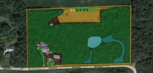
Yard Map program by Cornell Lab of Ornithology – Large scale
Today we are having a good old fashion rain day in Minnesota. It is days like these in March and April where many of start to think about our landscaping, yards and gardens. I have just come across a program that has blown me away! This is something I have always dreamed about and look forward to seeing its many future uses. I have long been an advocate of citizen based science and this program I feel will do wonders for wildlife and for the people enjoying it.
In a nutshell – Yard Map is a mapping program that uses Google maps as a background. You find your yard on the map and then use the tools to start creating boxes of the different habitats you have in your yard and then you add objects such as bird feeders, bird houses, snaps, water features, trees, vines.. etc.
This program also can sync up with the other citizen based science programs from Cornell like eBird! Now you can map out your yard and edit the data over time. Instead of having your drawings in your file cabinet it is now online for others to see and learn from.
Here are some of the many benefits and uses I see:
- Many landscaping mapping software is cumbersome to use! A 5 year-old could use this software – they made it that easy!
- You can click on specific items such as a tree and search the data base of the different species in the drop down menu. How often to do have someone come over and say what kind of flower or bush is that? When you have hundreds of plants you often forget. Now you have a resource you can go back to and look it up!
- Home owners can share these maps with contractors, landscape designers and wildlife managers to help them get a better idea in how their yard is set-up. I can now help give more accurate birding or water feature advice to my friends say in California.
- A great way to keep track of what birds are using what trees. When you add an object such as a snag(dead tree) to your map you can go back and add comments to that object. Now when a Northern Flicker makes a nest inside of the snag you can record it and see if they use the same snag year after year. You can also attach pictures of the actual snag for others to see! You could do this type of thing with all the plantings in your landscape!
- Your data is used by scientists from the Cornell Lab of Ornithology – Citizen based science project at work!
- Information overload – This program is packed with all types of tips on how you can improve your yard. You can also “Share” your yard on social media sites and start having discussions.
I encourage everyone to check out this program and help unlock many of its great uses. I have shared what I have so far in my yard at the larger scale. As I get the time I will start to re-size the trees and plants and get them down to the micro-level. Every plant will be mapped out down to the smallest detail! I plan to map out all of the good snags in my forest and keep track of what birds are using them. Personally I would love to see species specific discussions on what plants birds are using. Often we hear such and such a plant is “good for birds.” That is all fine and good, but I want to know down to what species… what time of year. .. A goal of mine is to have my favorite bird, the white-winged crossbills, visit my yard one day! What species of spruce are people having the most success with? What type of cover are the Varied Thrushes using when they show up in the winter? What type of berries are the Eastern Bluebirds eating in early April? We now have a platform where these types of discussions can take place! Amazing!!!!
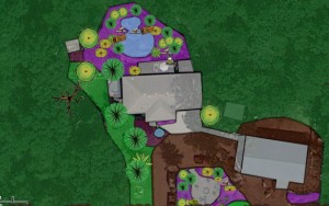
Backyard Habitat – Yard Map program by Cornell Lab of Ornithology
I would love to hear your stories and see you post your yards in the comments section of this blog!
Have fun!
Jake Langeslag “The Pondologist”

